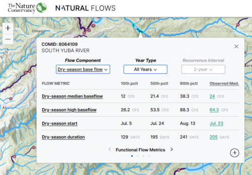
Natural Flows Database
The Nature Conservancy and partners have generated estimates of natural flows (expected streamflow in the absence of human modification) in all the streams and rivers in California. Two datasets are available: 1) natural functional flow metrics to support the California Environmental Flows Framework and 2) monthly natural flows from 1950-2021. Data can be queried directly using an API or visualized and downloaded with a map-based application that allows the user to search for stream segments and download flow data from an intuitive graphical user interface. Access the Natural Flows Database here.
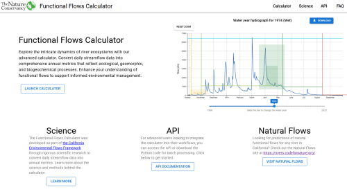
Functional Flows Calculator
The Functional Flows Calculator (FFC) quantifies functional flow metrics from a hydrologic time series. It includes tools for visualizing, downloading, and exploring California's streamflow patterns, including predicted unimpaired flows and functional flow metrics. Access the functional flows calculator here. Details on the reference FFC can be found in Patterson et al. 2020 (see publications page). You can find additional documentation regarding updates to the FFC, including metrics calculated for Flashy streams attached below.
R Package for Obtaining Functional Flow Metrics
An R package has been developed that allows users to access the Functional Flows Calculator directly via an API. The package allows users to:
- Retrieve streamflow data automatically from USGS or transform user-uploaded streamflow timeseries and run them through the functional flow calculator online,
- Obtain modeled functional flow metrics for a stream reach (NHD COMID) of interest,
- Create plots of dimensionless hydrographs using input flow data, and
- Compare observed and natural functional flow metrics to assess flow alteration at a given location.
The package is available on GitHub.
Functional Flows Calculator for Flashy Metrics (FFC-F)
While the Functional Flows Calculator (FFC) performs well in perennial streams with natural and seasonal flows, challenges arise when applying the FFC to flashy ephemeral streams or highly altered river systems affected by dams or diversions, resulting in inaccurate metric calculations and assessments. To address these challenges, the Functional Flows Calculator - Flashy (FFC-F) was developed to accurately calculate functional flow metrics in naturally flashy streams and highly altered river systems. Two new metrics were defined and included to better describe differences between altered and natural flow regimes, including the maximum rate of change of the spring recession and the difference between the fall pulse magnitude and the previous dry season baseflow. The result is an updated toolset that more accurately calculates functional flow metrics and characterizes flow regimes across the diversity of streams in California. A report describing the FFC-F metrics and their calculations is available for download here. The FFC-F can be accessed via the FFC.
Umbrella Species and Functional Flow Needs
Umbrella fish species and their functional flow requirements were identified for California. Access the map here, or begin using the map below by clicking "OK". The map displays the umbrella species for California; users may click on a watershed to view regional fish species assemblages (where each assemblage is represented by a different color), the umbrella species associated with each assemblage, and the HUC 12 distributions that comprise these assemblages outlined in gray. Functional flow needs for each umbrella species are available in the attached Excel workbook. For further details on how umbrella species were identified, see Obester et al. 2021.